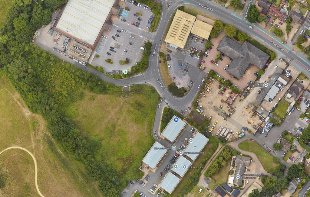
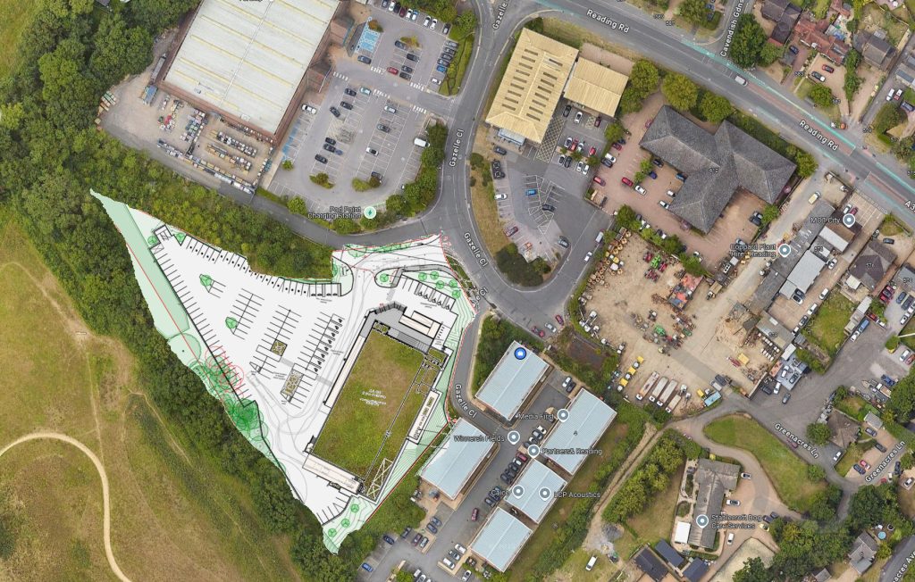
As someone who spends more time in Gazelle Close than probably any other person alive, I do want to make it clear how worrying this development proposal is.
- There are no people in proximity of this site other than the houses on Reading road. There are no people who can easily walk there. The only option would be to drive into a turning that only allows people to turn left to exit.
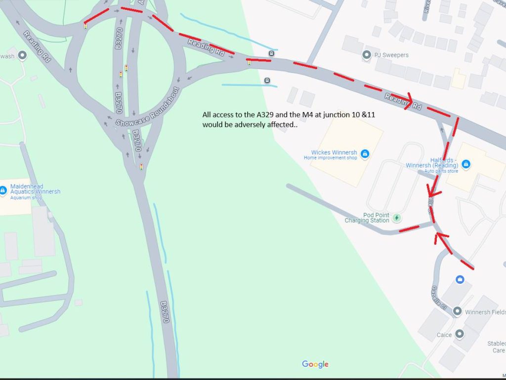
- The backlog of traffic onto the roundabout and the huge congestion that would be caused it inevitable. It will reduce quality of life to that of living in outer London. This is not acceptable to those of us who have to work here every day.
- You are introducing a new type of traffic that has never been present here before – families. This is not a traffic that shares any resource with Vehicle or Hardware superstores – this is not going to be subject to normal calculation regarding increased traffic. The situation needs to be re-examined.
- In every direction there is a supermarket already, why would you wish to ruin a major thoroughfare for the sake of such a small one? If it is for local people, where are they coming from? Small shopping is already supported adequately by the garage towards Woodley and Lower Earley has all manner of shopping facilities.
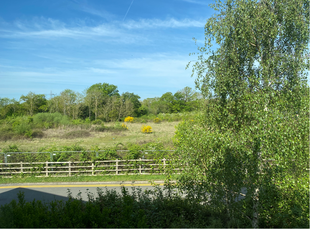
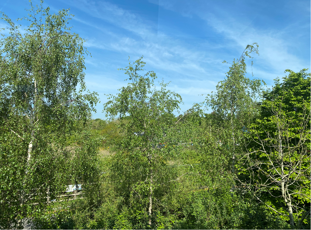
- Environmentally this would be a catastrophe. The deer that live by the hardware superstore would certainly die and our only solace from concrete and carp-parks would be gone forever. An additional and huge impact upon our daily lives to be suffered by all in our workplace; we have no visibility to any other green area.
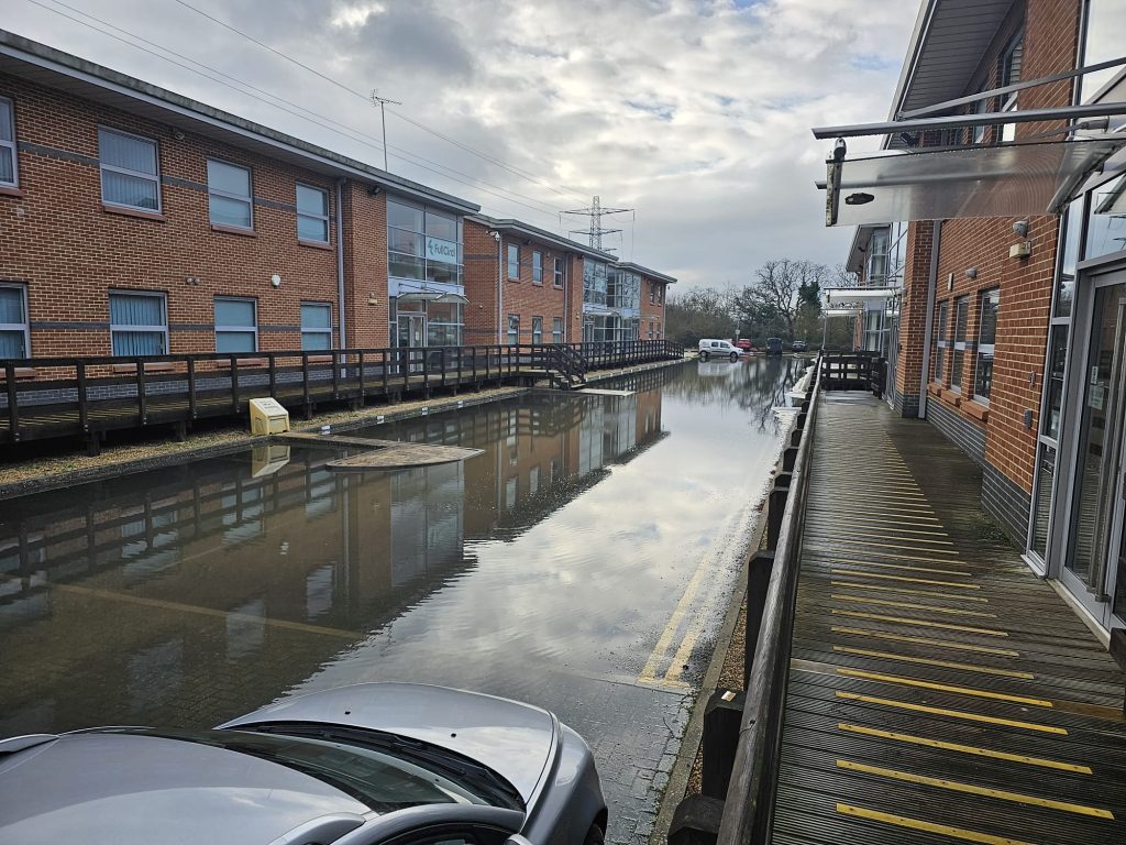
- There is also a problem here with water drainage. What would be the plans for protecting the car park from this? Once the car park is full of water and cars, the whole set-up will be at sea.
- A heavy plant hire service run through this access already. How is that going to work? They have access right outside our office and they would be queuing up on the other side of the road and taking the space of many cars, increasing blockages at the roundabout for motorway access. I just can’t see how the situation could be less suited.
Whatever the thinking is behind this, I implore you to reconsider your recommendations. The application had been put on hold due to flooding concerns but Aldi have obviously found a way to reverse any negativity being felt towards the notion, even though flooding is an ongoing problem around the site:

Apart from that the devastation of the last deer refuge in our area is about to be destroyed and we will have to watch the whole process every time we look out of the window, a truly distressing thought!
As we can see from the videos below, there are still a great many problems with drainage in the area and the Aldi will certainly increase problems for the new houses in the area as well as the offices at Winnersh Fields and the Halfords and Wickes superstores.
I have received a response in which they proceeded to ignore everything, but this is exactly what we suspected that they would do. They claim they have made some sort of calculation regarding traffic but it has no foundation that they can explain. Here is the latest:
“To:- All Committee Members
PLANNING COMMITTEE – WEDNESDAY, 30TH APRIL, 2025
I am now able to enclose, for consideration at the next Wednesday, 30th April, 2025 meeting of the
Planning Committee, the following reports that were marked as ‘to follow’ on the agenda sent out
recently.
Agenda No Item 50. Application no 230099 Aldi Stores Limited (Pages 3 – 8)
RECOMMENDATION: Conditional Approval subject to legal agreement
Supplementary Planning Agenda
Planning Committee
SUPPLEMENTARY UPDATE AGENDA
Extraordinary Planning Committee – 30th April 2025
Planning Applications
Agenda Item: 50
Site Address: LAND TO THE SOUTH OF GAZELLE CLOSE, WINNERSH, RG41
5HH
Application No: 230099
Two additional representations have been received following the publication of the
agenda seeking further clarification on certain issues. Whilst this item is solely
concerned with the committee agreeing to withdraw their objection regarding drainage
and flooding, for completeness some of these matters are addressed again below.
The application is now supported by a drainage scheme that increases flood water
storage. A flood response plan is required by condition 13 to ensure appropriate
evacuation should a flooding event occur.
The drainage systems are sized to contain below ground up to and including the 1 in
100-year plus climate change rainfall event on the site, as per national guidance, and
combined scenarios of such a rainfall event occurring while a fluvial (river) flood event
also occurs on the site have been assessed. When compared to the pre-development
scenario, there will be a greater capacity for flood water on the post-development site,
therefore there would be no increase in flood risk elsewhere.
The underground storage system was split, first into two tanks and latterly into three
tanks after further discussions, with different outlet levels, each provided with flap
valves after the flow controls. This enables higher parts of the scheme to still provide
storage when the lower parts have filled and the outlets closed by rising external flood
levels.
The volume of storage provided has been increased by 69% from the original 389.025
m3 to 657.3 m3, split between the three tanks. The rate of discharge from the tanks
remained unchanged and is the greenfield runoff rate for a 1 in 1 year storm. As above
the systems are sized to current guidance and in the event of an extreme flood (an
exceedance scenario), there would be no increase in off-site flood risk.
A maintenance regime for the drainage systems and flood mitigation measures will be
agreed via recommended condition 25. It is anticipated that preventative maintenance
to the drainage system (including removal of silt, debris etc.) will be undertaken several
times a year.
Both proposed drainage systems incorporate pollution treatment, with final details to
be agreed under condition discharge, which will reduce the risk of pollution from the
site to downstream water bodies. The systems discharge to a 600mm diameter
Thames Water surface water sewer within the site, which eventually outfalls to the
Loddon. The systems discharge to the sewer at a restricted rate, equivalent to the
estimated greenfield rate, and therefore will not contribute a significant additional flow
rate to the sewer and the river, so will not alter the existing flow regime in the Loddon.
3 Agenda Item 50.
Supplementary Planning Agenda
Planning Committee
Thames Water has confirmed there is adequate capacity in the network for the
proposed drainage system.
Whilst a need for the supermarket is not a material consideration, the retail impact of
the development has been considered and found that there is capacity for a new
supermarket in the area and that existing nearby stores are overtrading. The
committee has previous considered the retail impact acceptable and there are no
material reasons that warrant a different conclusion.
The planning policy Team advised the following at the time the application was
submitted:
‘The 2017 Study [Western Berkshire Retail and Commercial Leisure Assessment
(2017 Study] demonstrated some level of over-trading of convenience goods
stores in Wokingham Borough. Emerging retail evidence indicates that this has
continued to improve, with strong trading performances and in many cases
supermarkets trading significantly above ‘benchmark’ levels (over-trading).
There is also an indication that there is still a need for further convenience goods
floorspace across the borough. As such, it is unlikely that a foodstore in this
location would have significant impacts on the existing convenience
goods/supermarkets in the catchment area.’
The Wokingham Retail & Leisure Study – 2022 Update has been published and this
indicates a continued trend of strong performance and overtrading. Para 8.26 states
‘This positive requirement is largely being driven by the strong trading performance of
the existing network of foodstores in the Borough, a number of which are trading at
significantly above ‘benchmark’ levels and are therefore considered to be heavily
‘overtrading’.’ Stores identified as trading strongly were Aldi at Elms Fields, Tesco,
Wokingham and Sainsbury in Winnersh. Whilst there are supermarkets in the area,
there is capacity for additional stores without detrimentally impacting existing retail
centres.
In response to highway and sustainability issues raised by one additional
representation, the application has been considered two times by the Planning
Committee and the sole reason for the formal objection in June 2024 was due to
flooding and drainage, which officers are now recommending has been addressed. No
highway issues have been previously raised as a formal objection and there has been
no material changes in circumstances or policy that would warrant raising new
objections inconsistent with previous officer recommendations and committee
decisions. The following points are to address the representation submitted. This
information was provided at the time of the December 2023 committee meeting and is
again reiterated here.
The maximum recommended walking distance in the council’s Guidance Living
Streets is 1200m and there are a significant number of residential dwellings within this
catchment, including large areas of Winnersh and Earley. The application site is within
a sustainable location with good pedestrian infrastructure and public transport links.
There are nearby bus stops served by the 4 Lion Bus and Winnersh Triangle Train
Station is less than 400m from the site. Reading Road also has cycles lanes and
4 Supplementary Planning Agenda
Planning Committee
signalled crossing points. This is set out in paragraphs 33 – 37 in the original December
committee report (Appendix 1)
Junction modelling for 2026 was forecast that for Gazelle Close there would be an
average queue over the hour of 1 vehicle in the PM peak (17:00 – 18:00) and there
would be 1 vehicle waiting to turn right into Gazelle Road. With the supermarket in
operation, the average queue over the same period would be 8 and 4 vehicles during
the same peak hour, respectively. The council’s Highway Engineer advises that this
does not have a major impact on the operation of this junction and would not have a
significant impact on vehicles, including buses on Reading Road.
The highway information submitted states that in the weekday PM peak (17:00 –
18:00) the development would result in an additional 64 movements to the site and 54
movements out. Overall, this equates to an approximate 7% increase in vehicle trips
when considering all movements along this section of Reading Road during the same
period. The PM peak was chosen above the AM peak because it is a busier period
and therefore represents a worst-case scenario.
During the Saturday peak (13:00 – 14:00), the development would result in a 17%
increase in two-way traffic along Reading Road. With an additional 121 vehicle
movements to the site and 162 outward.
Whilst Gazelle Close serves multiple commercial business, the road has limited traffic
and can accommodate the proposed development. Traffic Regulation Orders can
control existing on-street parking to limit obstacles to vehicle using the road and is
included in the S106 agreement.
Para 116 of the NPPF states that ‘development should only be prevented or refused
on highways grounds if there would be an unacceptable impact on highway safety, or
the residual cumulative impacts on the road network, following mitigation, would be
severe, taking into account all reasonable future scenarios.’ The proposed
development would not impact highway safety or cumulatively result in severe impacts
on the network. The council’s Highway Engineer is satisfied that the highway network
can accommodate the vehicle movements associate with the development.
The following amendments to the conditions were included in the December 2023
supplementary agenda are also included here for clarity and completeness.
It is recommended that condition 25 is amended to include an additional clause (iv)
that specifically refers to the management and maintenance of such voids:
Flooding and drainage
No building hereby permitted shall be occupied until surface water drainage and flood
mitigation works have been implemented in accordance with details that have been
submitted to and approved in writing by the local planning authority. the submitted
details shall include:
i) provide information about the design storm period and intensity, the method
employed to delay and control the surface water discharged from the site and the
5 Supplementary Planning Agenda
Planning Committee
measures taken to prevent pollution of the receiving groundwater and/or surface
waters; ii) include a timetable for its implementation; and iii) provide a management
and maintenance plan for the lifetime of the development which shall include the
arrangements for adoption by any public authority or statutory undertaker and any
other arrangements to secure the operation of the scheme throughout its lifetime.
iv) an effective management and maintenance plan which directly ensures voids
underneath the building are regularly inspected, maintained and kept free of
obstruction and debris for the lifetime of the development.
Reason: To prevent increased flood risk from surface water run-off. Relevant policy:
NPPF Section 10 (Meeting the Challenge of Climate Change, Flooding and Coastal
Change), Core Strategy policy CP1 and Managing Development Delivery Local Plan
policies CC09 and CC10
Following a review of the conditions, the trigger to conditions 12, 19, 26 is
recommended to be changed to ‘prior to the occupation’. The conditions would read
as follows:
Landscape management
Prior to the commencement occupation of the development a landscape management
plan, including long term design objectives, management responsibilities, timescales
and maintenance schedules for all landscape areas, other than privately owned,
domestic gardens, shall be submitted to and approved in writing by the local planning
authority. The landscape management plan shall be carried out as approved.
Reason: In order to ensure that provision is made to allow satisfactory maintenance
of the landscaping hereby approved. Relevant policy: Core Strategy policy CP3 and
Managing Development Delivery Local Plan policies CC03 and TB21.
Travel plan
Prior to the commencement occupation of the development a Travel Plan shall be
submitted to and approved in writing by the local planning authority. The travel plan
shall include a programme of implementation and proposals to promote alternative
forms of transport to and from the site, other than by the private car and provide for
periodic review. The travel plan shall be fully implemented, maintained and reviewed
as so approved.
Reason: To encourage the use of all travel modes. Relevant policy: NPPF Section 4
(Sustainable Transport) and Core Strategy policy CP6.
Flood Response Plan
Prior to the commencement occupation of the development hereby approved, a Flood
Response Plan shall be submitted to and approved in writing by the Local Planning
Authority. The details thereby agreed shall be implemented in perpetuity unless
otherwise first agreed in writing by the Local Planning Authority.
6 Supplementary Planning Agenda
Planning Committee
Reason: To ensure the development is flood resilient and remains safe during flooding
events.
The trigger to condition 13 is recommended to be change to ‘prior to the erection of
the supermarket building’. It would therefore read as follows:
Sustainable design
Prior to the commencement of development erection of the supermarket building full
details of how the development will achieve a 10% reduction in carbon emissions shall
be submitted to and approved in writing by the Local Planning Authority. The details
thereby agreed shall be fully implemented and maintained in working order in
perpetuity.
Reason: To ensure the development results in a 10% reduction in carbon emissions
in accordance with policy CC05 “
Well, they have not started building anything as of yet, but I do not know if that was the final straw and they are just organising findong the sort of people who can destroy woodland and then go home and sleep at night. It will drastically altrer our work expereince here as well as our experience trying to get in and out of work. It will also mean that there are groups of people here late into the night and far more human traffic as well as road traffic than ever before. I think it will be the end of Winnersh Fields to be quite honest. We will no longer wish to stay here at least.